Friday, February 24, 2017

History revealed

My last post was about a hole in history regarding Tennessee Pass's narrow gauge alignment, for me anyhow.  Thanks to the endless depth of knowledge of the D&RGW Yahoo Group, resources and information were produced and I now have a much clearer vision of history between Malta and Minturn.


So lets review:
Ormes Tracking Ghost Railroads in Colorado depicts a map with the differing alignment between Crane Park and Mitchell.  For this he is correct, however his depiction of the alignment at Crane Park does not jive with satellite imagery for where the original NG alignment was, or even where it was planned.
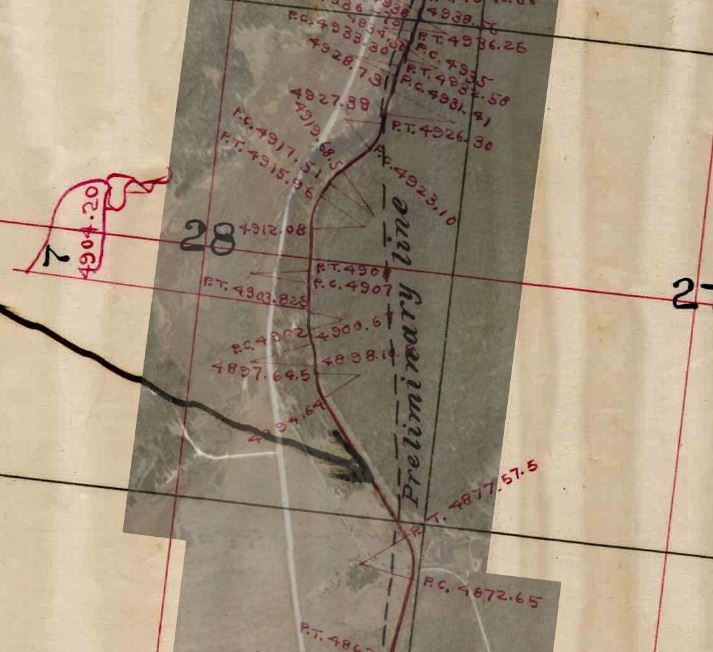
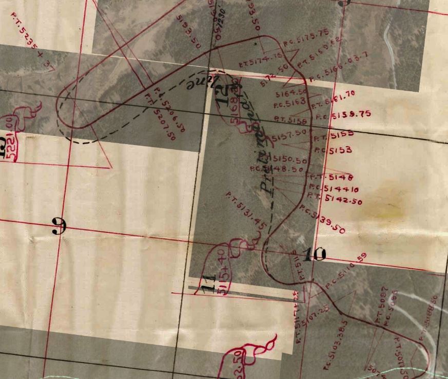
The 1882/3 D&RG survey map shows a loop as a preliminary line loosely where Ormes puts his, but again this was not the alignment built.
From there on to Mitchell Ormes has it right.

LeMassena indicates the alignment changes were between Keeldar and Pando.  Which is accurate, to a point.  At Keeldar the only evidence I see is a straightening of a short segment of the ROW following the creek, with the major changes starting in Crane Park.

Neither account for the alignment changes between Pando and Red Cliff though.


Between Keeldar and Crane Park it appears the D&RG planned a tunnel or large cut, but decided otherwise.  The NG alignment is the SG alignment.


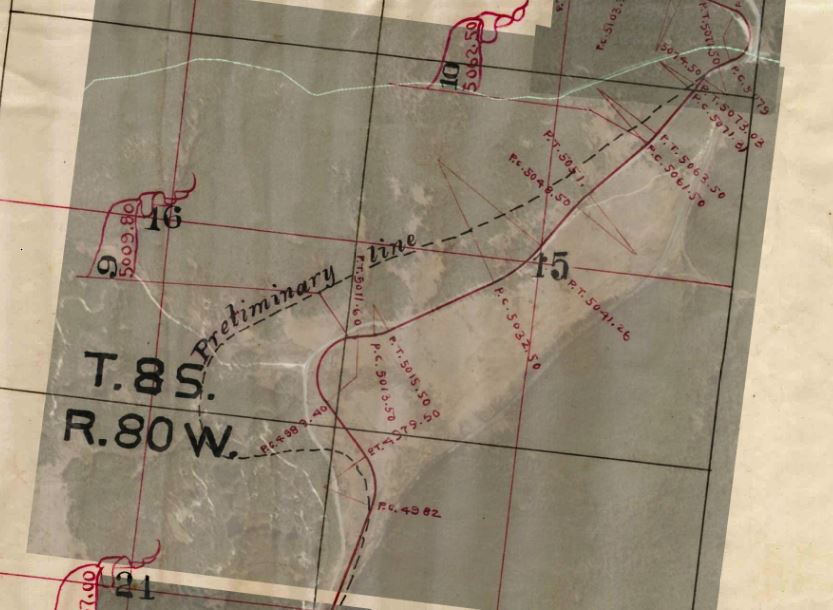
Here is the Crane Park to TennPass alignment of the 1883 survey map vs. Google Earth.  Ormes closely depicts the preliminary line (not overlayed, his depiction is somewhere between the two curve/loops)


Over the pass the D&RG surveyed a different line and built elsewhere as well.


Through Eagle Park to Pando is interesting.  The W H Jackson photo of Mount of the Holy Cross shows the original alignment; that's already been covered.  But no photo evidence has been sourced of the west end of Camp Hale and Pando area for the original NG alignment.  Doing the best I could with the overlays created an issue with the north end of Pando.  Either the survey map is generous with the length of the alignment in that area or I goofed somehow. But to get the Google Earth details to fit the survey map north Pando with the same scaling of the areas before and after Pando would have originally put the NG alignment HIGH on the hillside.  So the overlay shows a Google Earth 'studder' in the image... it is what it is.
As you can see though, Camp Hale did its best to destroy the NG alignment once it turned north.


Between Pando and Red Cliff there is evidence of the alignment changes.  What is not clear is if the original narrow gauge was standard gauged, then later realigned, or if the realignments occurred at the time of the SG'ing.  Because of how the two alignments come together at sections, and it appears the standard gauge is on a higher elevation in sections (especially entering Red Cliff), I would say it was a all-in-one change.
There is nothing interesting between Pando and Red Cliff to show Google Earth pictures of, and I have yet to find historic photos along that section, so I'll move on to Red Cliff.


Here is a shot (WHJ 10166) of Red Cliff between 1882 and 1900 with no signs of D&RG yet.  Because of the lack of a railroad this would put the picture 1880-1881.


It was mentioned that a NG roundhouse existed at Red Cliff and history seems to leave that information out.  It is captured in at least two pictures though.  Erdlens 1885 photo, and W H Jacksons photo from the same vantage point around the same time.   The copy of the Erdlen photo I've already shown in the previous blog is way too grainy to make out the roundhouse, depot, or water tower but the WHJ photo is very clear.  There is also an non-credited photo from the same location after the standard gauging that shows all of them gone.  On Google Earth the foundation for the water tower can still be seen, but the depot and roundhouse locations are not identifiable.

I created a gif of the WHJ and non-credited photo's to show the changes that took place.  The new SG looks like it built on top of the roundhouse with the depot being completely removed and just the water tower foundation left.  The SG alignment appears to enter at a much higher elevation as well.


The requirement for the roundhouse is pretty evident.  When this was just a branchline north from Malta the D&RG needed some place to turn the steam engines, but once the line was extended to Minturn and the roundhouse was built there Red Cliff lost that requirement.


Heading further west towards Minturn the original NG alignment was on the north side of Eagle River through to the end of the canyon.  West of Red Cliff the current Belden Siding was the original main line, and in 1907 a second standard gauge main line was built from Minturn to Red Cliff (info from drgw.net) which would be the current main line on the south side of Eagle River.

Compare the Google Earth view of the area to the next picture of the dual mainlines.

Picture of bridge in the low left center of the Google image.  Note the chute in the background for one of the many mines through the canyon.  The original NG mainline is the one on the right.


This arrangement lasted until 1958 (info from drgw.net) when the D&RGW converted this section to CTC control and converted the original mainline into passing sidings between Minturn and Pando (or Deen Tunnel).  Belden siding then and now exists from just west of Eagle Mine to the mouth of the canyon at the west end of Red Cliff.


Saturday, February 4, 2017

Can't see the Railroad for the trees... or Narrowly forgotten (my apologies to Rocky and Bullwinkle)

I'm going to diverge here for a bit from my layout posts and postulate about the D&RG's narrow gauge alignment over Tennessee Pass.

In doing endless research about TennPass there is almost a black hole regarding information about the narrow gauge alignment over the pass and down the west side, and there is a decisive lack of evidence in the form of photo's... well almost.

This is a bit long winded and at the end I really stretch reasoning on the second part but I hope you enjoy the read.


Let's start with what is known:
(The following information is available from many books and online sources but I've found that http://www.drgw.net/info/TennesseePass puts it all together very well in one spot)

  1. 1880 -  The narrow gauge Royal Gorge Route is extended to Malta
    1. then extended to Cranes Park south of the Tennessee Pass
  2. 1881 - The narrow gauge was extended over the Pass to Red Cliff
  3. 1882 - The narrow gauge was extended to Rock Creek
  4. 1882 to 1886 - Not much progress extending the line further west
  5. 1886 to 1887 - The narrow gauge was extended to Glenwood Springs (then Aspen) in a race against the Colorado Midland
  6. 1888 to 1890 - The first Tennessee Pass tunnel was constructed and utilized by the narrow gauge until dual gauge trackage made its way to Malta. TennPass tunnel was then standard gauged late in 1890
It is between the years of 1881 and 1890 in which history is devoid of information, at least as much as I have been able to research and read about.  It's during this time frame that the D&RG built the narrow gauge to Glenwood Springs, but also surveyed and built the standard gauge alignment, bored the tunnel, and left the original narrow gauge alignment to history.  Yet very little can be found about any of this. 

drgw.net makes a note about two authors (Robert LeMassena: Rio Grande to the Pacific, and Robert Ormes: Tracking Ghost Railroads in Colorado) with differeing statements about the new standard gauge alignment and where it varied from the narrow gauge alignment, and gives a nod to LeMassena having the correct information and I have to agree with this.


Present "history" is evident. We know where the current alignment is, and we know where the narrow gauge alignment went over the Pass down to where it intersects with the standard gauge alignment near Mitchell curves.  Then what? Where did the narrow gauge alignment go? Was the narrow gauge alignment on the present standard gauge alignment from Mitchell to Red Cliff?  Rt 24 parallels the current alignment dropping down into the valley, so is Rt 24 the original alignment until Pando?  Rt 24 is on the original alignment on the south side of the pass so this is a logical assumption.  Or is there another route?   This is where the cloud of history seems to fog up our historical camera lens.

But let's verify what is obvious through the eyes of Google Earth and re-assert some of the obvious.
At the East switch of the Tennessee Pass siding you can follow the NG alignment (orange) as it heads off to the west and in quick order becomes Hwy24. From here Hwy24 is on the NG alignment until the summit of the pass where the NG alignment becomes “Loop Trail” heading West and one would pass a couple coke oven foundations I believe. From there the alignment swoops back North loosely paralleling the present alignment. At the South end of Mitchell curves area the original NG alignment swings around the mountain and heads South West toward a 180* loop (Loop Trail diverts from the alignment here). 


Side Note: After rounding the 180* loop there is a bit of curiosity to be seen/found. A switch heads back South West towards the foot of the mountain and tree line, and there can be seen the foundations for approximately 14 coke ovens (presumably).  I have not been able to find any pictures or mentions of these coke ovens, only of the two at the summit of the pass.
(EDIT November 19, 2018:  looking over some division time tables from 1919 a comment on cars left at Mitchell states this.  "When cars are left at Mitchell they must be placed above switch leading to charcoal ovens and switch  must be set and locked for oven track.")


Staying along the original NG alignment after the 180* loop you head North East back towards the start (or West end) of Mitchell curves. At the point the original NG alignment meets the existing alignment, history, road work, and the standard gauge alignment work have obscured any evidence of the NG alignment at that specific spot. Also, at this spot because of the lack of NG alignment evidence it does give credence to Ormes claim that the realignment only existed between Mitchell and Crane Park. 


Here’s where I make a statement based on grading, fills, and curvature from looking on Google Earth that Ormes is not correct. If we state that the NG alignment continued on we can “trace” it along Hwy24 again to State Road 726, or Jones Gulch Rd. At this point, St Rd 726 is the NG alignment again. As it approaches the valley where Camp Hale existed the NG alignment hugged the mountain and turned East towards an almost 180* curve.
 At what I believe was the eastern end of Camp Hale the original NG alignment curved back West and becomes E Fork Eagle Rd, which I presume during the period of Camp Hale was probably used as a road. The NG alignment continues to stay on the opposite side of the valley from the new alignment as both alignments skirt the location of Camp Hale. 


Camp Hale appears to, and likely did, erase some of the NG alignment.  At the point of the West End of Pando siding appears to be about the area of the alignment diversions, which would coincide with LeMassena’s claim that the realignment was rather substantial and extended from Pando to Crane Park.  


Initially I thought if the narrow gauge alignment went through the site of Camp Hale and onto Red Cliff as just a branch line then Rt 24 might just be on the original alignment to Red Cliff, but let's back up before I get ahead of myself and revisit my proposed alignment through Camp Hale. 

Until recently I could not find any single newspaper article, photo, blurb, or even a careless historical thought about the original alignment west of TennPass.  That was until I stumbled upon a fairly recent (circa 2015 I think) article about a group(s) of people (Eagle County Watershed) wanting to return the area of Camp Hale to its former natural state, particularly concerning the Eagle River alignment (when the government built Camp Hale in 1942 they dug a straight ditch to contain the headwaters of the Eagle River and allow development of the army base.)  In this article they referenced the valley as Eagle Park, of which I hadn't heard before, and not being a Colorado resident if this is "local naming" I was not privy to it.  Googling "Eagle Park Colorado" doesn't produce much either. 

And then, somewhere in the back of my brain I recognized the term Eagle Park and dug into my deep digital collection of D&RG(W) photos.  What I thought was a complete void in history was graciously filmed by one William Henry Jackson in 1885 in what appears to be one single photo. 

Disembarked his photographers-special train, Mr Jackson pointed his lens towards the summit of Mount of the Holy Cross from a vantage in Eagle Park.  It's the peak in the top-center of the photo.


Until now this was an unrecognizable location for me.  I knew where Mt Holy Cross was, but from where was this photo taken?  Not until the mention of Eagle Park and Camp Hale did I put it all together that Jackson not only photographed the Mount of the Holy Cross, but also the original narrow gauge alignment of the D&RG through what is known as Camp Hale now. 

So how do I prove this?  By returning to Google Earth of course.  I already showed my interpretation of the narrow gauge alignment from Mitchell to the west end of present day Pando above, and this is how I confirm it. 

From this picture you can see the two alignments through the Eagle Park (Camp Hale) area and the location of Mount of the Holy Cross.  Also note that I am marking the location I believe Mr Jackson stood to photograph Holy Cross. 


From Mr Jackson's vantage point we know what his photo looked like, and this is what the view from Google Earth looks like. 


If you're still skeptical, please watch this overlay gif and study some identifiers. 
  1. The narrow gauge alignment is what I previously called out as being E Fork Eagle Rd.
  2. The absence and presence of the current D&RGW standard gauge alignment in the background.
  3. The location of Dean (Pando/Camp Hale) Tunnel


Thus putting a pin in my research of the original narrow gauge alignment.


The following pictures from 1885 of Red Cliff help to show the alignment change from NG to SG.  Nothing between Pando and Red Cliff can be found, but Google Earth suggests alignment changes through the river valley between both places. This photo by C W Erdlen (watermarked images borrowed from Colorado Artifactual website) looking southeast from the apex of Red Cliff.  Dead center of the photo we can see a wooden bridge.  This crosses the narrow gauge tracks which is the present alignment.   The main road shown at left is present day Eagle St.   Water Street, which is not identified, would be where the rows of houses stretch to the right from Eagle St just below center of the photo.

Image looking North.

Curiously, if you look at Google Earth and follow Eagle St south out of Red Cliff it becomes a dirt road that has all the evidence of old road bed, and in fact ends in the present day alignment. 


Movement in Minturn

From a bare deck to Minturn yard.  Compare the before and after pictures to see how much progress the track gang has made. 
Minturn yard and engine service area's are recreated semi faithfully, allowing for compression and some modelers license for better operations. Left to right are the Main, Siding, 3 yard tracks,  and then both engine areas are present.  Where the 3 'Tuns sit will be the engine service building. 


But let's back up a bit and enjoy some shots of the action I caught as a work train headed east through Minturn on its way to the present end of the line.  It looks like they are delivering a bulldozer to work on some main line grading east of the yard.


From this elevated view we catch the work train coming out of the yard heading towards the siding connection.  At left is the area where the Roundhouse was and the present day Wye is.  This is where I didn't follow the actual track arrangement faithfully.  The leftmost engine track should be two stub end  leads within the Wye, and the Wye should be curving off from either side of those engines towards the left of the picture.  Since the Wye was not going to be useful for me I saved the two switches for use elsewhere and made the engine track connect on both ends.


I got another shot of the work train leaving Minturn yard.  About where the homasote sections join is where Minturn Rd crosses the D&RGW tracks at grade. 

And if you're not familiar with Minturn, this is the area you'd be looking at.  Capture taken from Google Earth. 


A different view of the work train entering the siding as it exits Minturn yard.  


And rather quickly she meets the end of the line.  Lots of work to be done as spline roadbed will take over from here again.  That bulldozer is going to get a workout.

Friday, February 3, 2017

Minturn (Min'urn)

Finally, I've started on the main deck, building the foundation for what will be Minturn. We are standing basically at the west end of Minturn yard facing towards Tennessee Pass.  The deck here is as wide as the staging yard but will not have nearly as many tracks. 


1/2" homasote over 1/2" OSB.


And painted.

Wednesday, February 1, 2017

Change of mind brings change of scenery

The decision to go with a helix instead of a long continuous grade between the two decks meant certain areas require changing.  What was originally going to be a representation of Malta now becomes the general area of Belden siding with intentions to model (somewhat) the Eagle Mine, and possibly a couple of the smaller mines along the canyon in order to have some switching on this otherwise bridge-traffic-only layout. 

I decided to give homasote splines a shot and they really work well. They take some time to work with to bend them into the proper radius as it won't form a uniform curve along the length you intend to curve but it's not a chore to do either.  And since I spike my track down this method is fantastic. 

The work train here is entering the siding from the one staging connection.  The splines will be painted black as I've done before with the homasote, but track was laid quickly to keep my son occupied watching trains while I worked on other parts of the layout.


Staging will still connect to this area as before.  The track the train is on is the staging connection. From left to right is the staging connection, Belden siding, Eagle River, and the main line.  All the homasote will be elevated here with the staging connection starting its decent rather quickly after leaving the siding.
Eagle mine will be represented about where the 3 tunnel motors are sitting now.